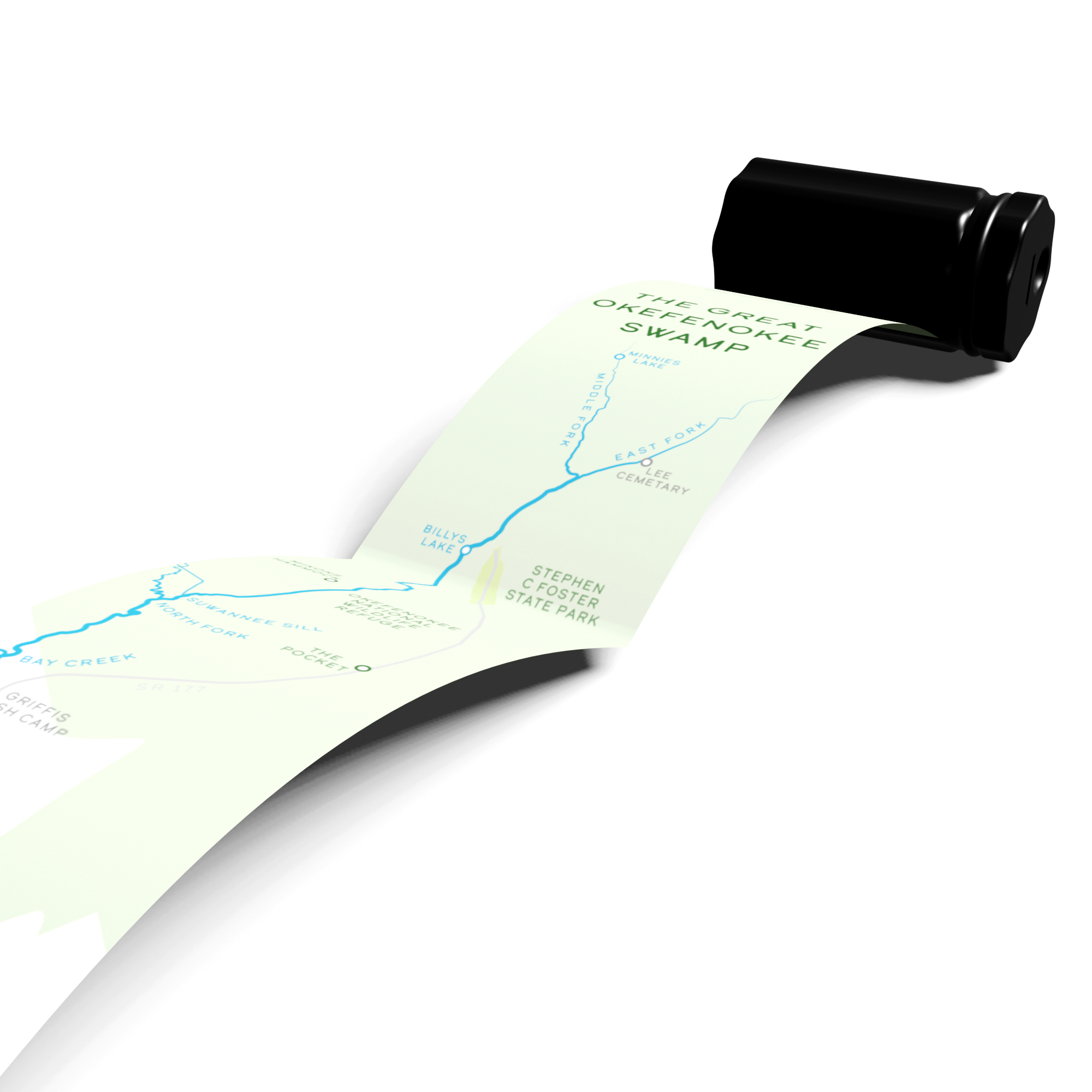
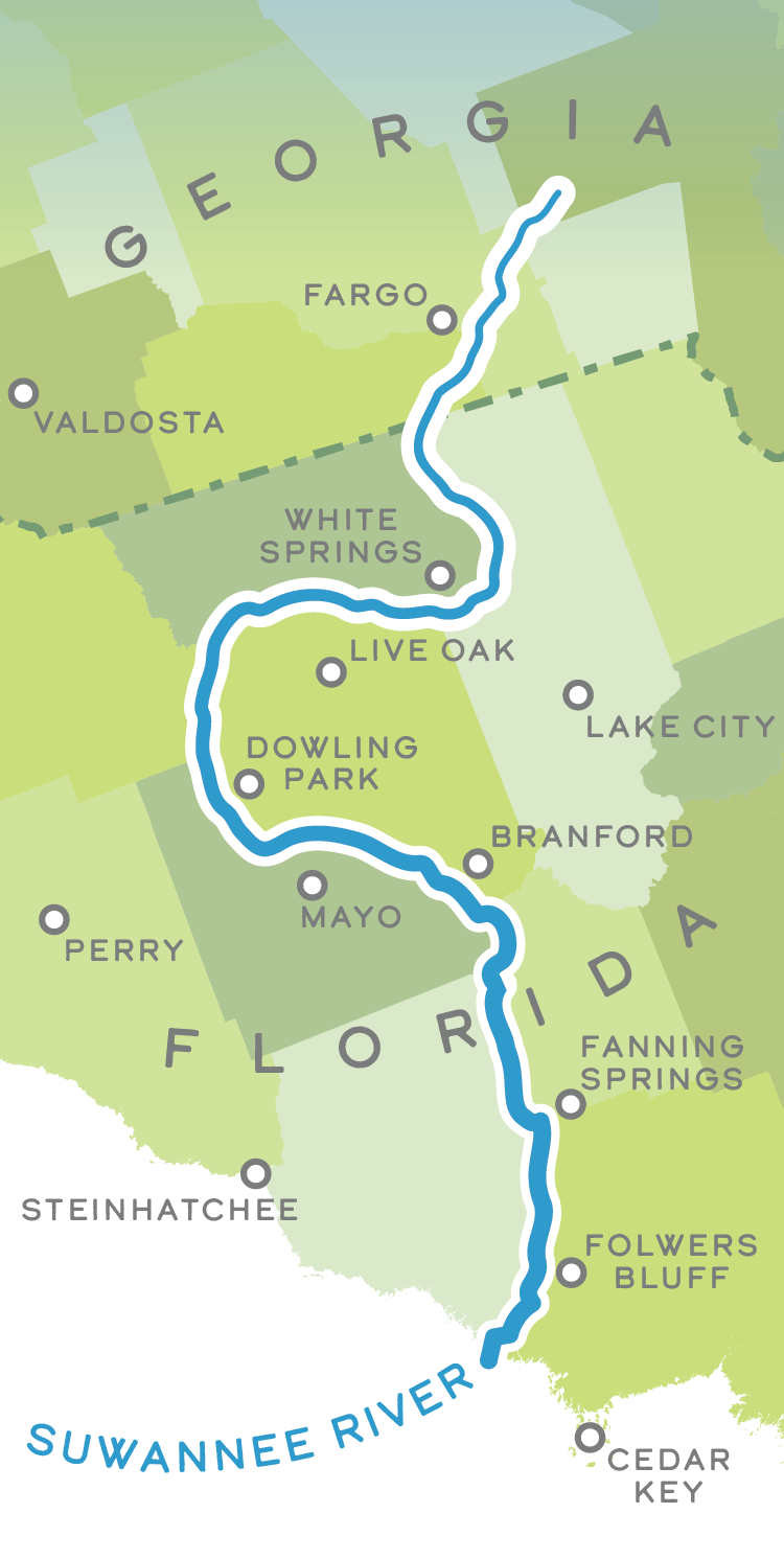
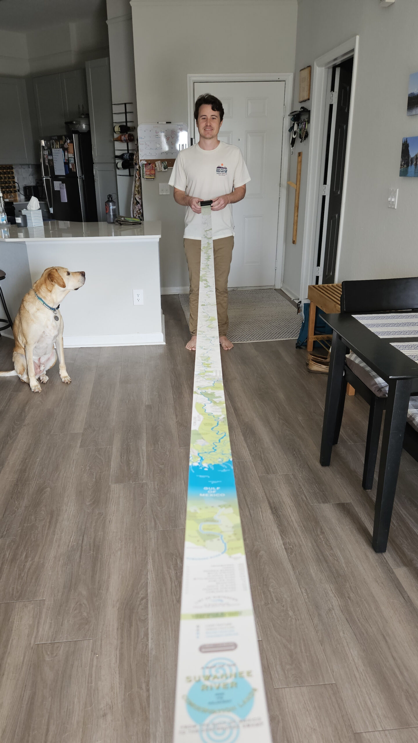
This 12 foot by 2.5 inch ribbon map shows the Suwannee River and its adjacent conservation lands, from the headwaters at Georgia’s Okefenokee Swamp to the Florida Gulf Coast. The map was made using Adobe Illustrator, and draws inspiration from similar ‘ribbon maps’ of the mid 19th century—the primary example being the Ribbon Map of the Father of Waters (Mississippi River) by Coloney & Fairchild, 1886. It is meant to be read from the bottom up, (travelling upriver) as it is drawn out from a wind-up container. If you’re on mobile and want to skip to the full map, tap here.
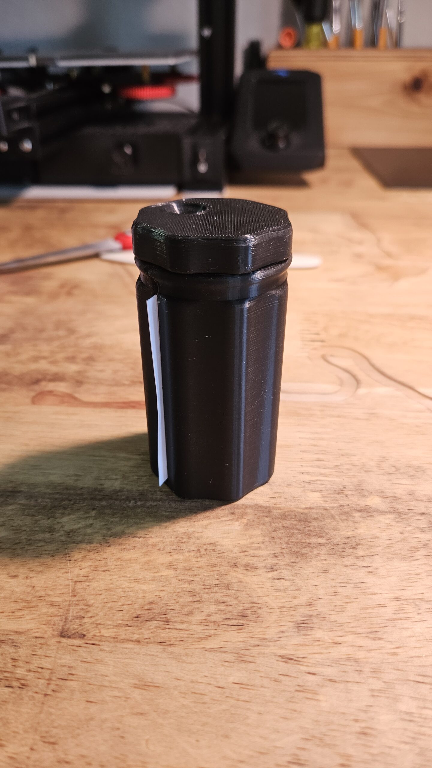
The container is based on a design by Relaxed Maker and was originally meant as a measuring tape holder. I simply elongated the original model in Blender, removed the screwdriver slot (which I didn’t see much use for here), and remade the finger dimple to be a smidge deeper and help to prevent slipping (although it’s still not particularly useful. It looks useful, though!). If you want to 3D print your own ribbon map container, I’ve uploaded my remixed version to Printables.
While the map is simplistic in appearance, virtually every feature needed to be manually adjusted or positioned by hand. The Suwannee River is not a particularly straight one. It has long, sweeping curves when viewed at small scales and tight, hairpin turns when inspected up close. So I had to plan ahead of time where I wanted to add ‘break points’ to the river and then, segment by segment, rotate all objects below each point, straightening everything out on the grander scheme of things while preserving the smaller bends and local geography. This means that the north orientation is always in flux, though I tried to hide where exactly it shifts. Since most of the adjacent conservation lands go right up to the river bank, I often had to redraw some approximated boundaries around these breaks that, while technically inaccurate, made sense visually.
Originally, I was hoping to make the map only an inch wide, for no reason other than to make it as ridiculous as possible. But after some quick tests I realized I wouldn’t’ be able to fit much of anything else on it besides the river. So instead, I sized it up to two and a half inches—and even that ended up being a challenge. The areas around White Springs, Suwannee River State Park, Peacock Springs, Fanning Springs, and the network of small creeks at the Gulf were a particularly thrilling game of Cartographer’s Tetris.
While the river and its nearby conservation lands (mostly based on the Florida Natural Areas Inventory) were the main focus of the map, I tried to pack in lots of other points of interest wherever I could. The Suwannee is full of beautiful blue springs, some rather large and famous, others just nameless holes in the bedrock the size of your fist, and I included as many as possible using both available GIS data as well as field reports from the local water management district. Many of the place names (both natural and urban) are from the US Board of Geographic Names, but others I added based on fun tidbits I found while researching the adjacent areas, like defunct and historic bridges and landings, or small municipal parks that would be identifiable to locals. I also included cemeteries, as I do on many of my maps, as they are (mostly) permanent points of reference that often hint at the history of the place. Look up Charles Spring/Ferry/Cemetery just south of Dowling Park, for example, to get an odd tale of local legend. Lastly, I made sure that each road, ferry, and railroad crossing made it on to the map, as there are surprisingly few given the river’s 246 miles of length, and proximity to these crossings often dictated where communities popped up (railroads and the turpentine industry being the other big factors).
The conservation lands along the Suwannee River are an interesting patchwork of state, federal, and private easements. Given the small workspace, I wanted to avoid using outlines on these boundaries to reduce visual clutter, but these properties often border right on top of one another, blending together. So I opted to give each one a slightly different shade (and/or tint) of green to help denote where one parcel gave way to another. As a starting point, I used the Randomus script by Alexander Ladygin to apply various shades of green randomly across the conservation lands. Then, I went through the map and made sure that any multi-part areas (for example, a park with two separate polygons on either side of the river) had the same shade of green to keep them visually associated.
For the labels, I added knockouts over the roads, railways, and Florida National Scenic Trail using a method outlined by Daniel Huffman in his blogpost, Even Fancier Type Knockouts in Illustrator. Immensely helpful trick. The typeface used across the map is Calder Dark. I typically stuck to one label for each conservation area, even when it had multiple parcels spanning for miles up and down the river. In most cases, you can look for the nearest polygon with a label that shares the same color and know which group it’s a part of.
To print, I split the map into four, 36-inch segments and arranged them on a single layout with faint guides for cutting. Then, I sliced and assembled everything together using regular old clear packing tape. If you want to try putting together your own copy of this map, I’ve uploaded the print file here. I recommend cutting the short sides to length first, then splitting the four segments apart from each other. A piece of packing tape wrapped around each seam roughly 5 inches long is plenty strong enough to hold things together, and if you also cut the tape in half lengthwise, it will prevent the seam from warping too much when stored in the container for long periods.
While I’m always looking at a lot of different maps and resources online over the course of each project, I’ve lately gotten into the habit of grabbing an honest-to-goodness book, as well. Something that’s part research and part pleasure—a little less dry than the articles, reports, journals, and raw GIS data I’m already going over. It can be a palette cleanser and also help get my mind in a certain place (both figuratively and geographically speaking) even if the subject is only loosely related to my project. At the very least, I can often glean a few juicy details to incorporate on the map. For my Lignumvitae Key Map last year, I read Last Train to Paradise by Les Standiford, which barely mentioned the island on my map as the construction of Henry Flagler’s Overseas Railroad blew past it—but it still gave some great perspective on the history of the area and why that island remains so undeveloped. For this project, I read the book Suwannee River, Strange Green Land by Cecile Hulse Matschat, published in 1938. I don’t think it directly influenced the inclusion of anything specific on this map, but it was a pretty fascinating blend of fiction and non-fiction that served as a time capsule of what the region was like nearly 100 years ago, and how it came to its current state. It’s also packed with beautiful illustrations. Highly recommend.
The Suwannee River has this odd quality of being widely described as famous and historic while also remaining relatively obscure. That’s because its primary claim to fame is an 1851 song called “Old Folks at Home”, written by American songwriter Stephen C. Foster (a name that appears multiple times on this map), also known as “the Father of American Music”. It’s also the official state song of Florida (undergoing multiple rewrites to its dated lyrics since), and blues aficionados might recognize it in the form of Swanee River Boogie by Albert Ammons. Multiple crossings, including Interstate 10, have big green signs announcing the “Historic Suwannee River”, with a bit of music notation from the song beneath. As a native Floridian, it’s one of those things you see and occasionally hear and assume the river must indeed be famous, because it’s only ever described as such—but ask anyone outside of north Florida or south Georgia about it and there’s a good chance they’ll have no idea what river you’re talking about.
I was eventually disappointed to learn on a visit to Stephen Foster Folk Culture Center State Park, near White Springs, that Stephen Foster wasn’t even from Florida. In fact, he’d never even been to Florida, let alone seen the river he made famous. He simply liked the sound of it when plugged into a piece he was already working on, and the song could be about any river in the south. I don’t bring this up to rag on the song or Stephen Foster—I mention it because one of the reasons I chose to focus this map on the Suwannee was so that I could learn more about what actually made the river interesting. And I found that the Suwannee is indeed a pretty fascinating river in its own right. Given the rapid development of Florida over the past century, the river remains surprisingly unspoiled and pristine, as supported by the hundreds of conservation areas on this map. It carries fresh water from the largest blackwater swamp in North America (another under appreciated gem) to the highly productive estuaries of the Gulf Coast, and is a vital watershed in the state that has supported humans and wildlife for thousands of years. If one goes looking, you’ll find plenty of historical and cultural tidbits about the river and how it shaped human history in the area, from pirates hiding in the maze of creeks at its mouth, to Florida’s nascent tourism industry built around mineral spring bathing, and to the isolated swamp communities of south Georgia who spoke Elizabethan English well into the 20th century.
Finally, here is an incomplete list of the maps I drew inspiration from for this project, and if you are interested in creating your own ribbon map, might inspire you as well!
| Map | Link |
|---|---|
| Ribbon Map of the Father of Waters, Coloney, Fairchild & Co, 1866 | Link |
| The Oarman’s And Angler’s Map Of The River Thames From Its Source To London Bridge, Reynolds & Sons, 1883 | Link |
| Map Of The Hudson River, The Western Canal, And Stage Road, Robert J Vandewater, 1830 | Link |
| Idris Mathias’s manuscript map of the lower Teifi valley, Idris Mathias, 1962 | Link |
| Map of Savannah River, David F Hillhouse, 1853 | Link |
| Principal Rivers of the World, Samuel Augustus Mitchell, 1849 | Link |
| The Roads through England Delineated, John Ogilby, 1675 | Link |
| River of Ohio, Harry Gordon, 1766 | Link |
| Map of the rivers Huallaga, Ucayali & Amazon, John Tyssowski, 1852 | Link |
| Lloyd’s map of the Lower Mississippi River from St. Louis to the Gulf of Mexico, J.T. Loyd, 1862 | Link |
Next, maybe I’ll try and tackle this bizarre 1920’s wrist watch navigation system.
